
Road-Tripping the Sacred Southwest: Grand Canyon, Horseshoe Bend & Monument Valley
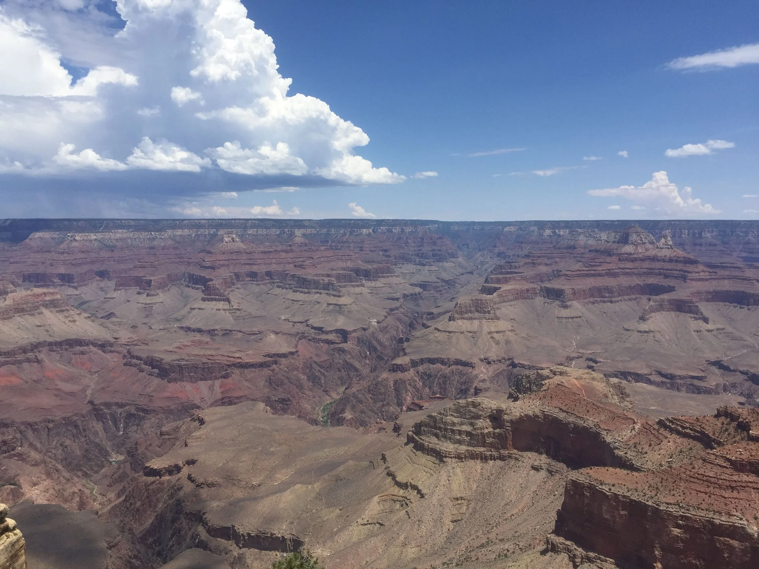
Grand Canyon South Rim
Some of the most recognizable landscapes in the world sit within a day’s drive of each other in the American Southwest: the Grand Canyon, Horseshoe Bend on the Colorado River, and the sandstone towers of Monument Valley. We drove this circuit a few months back, and it’s the kind of road trip that reminds you why you travel in the first place — and why you travel slowly.
It’s also a trip that asks more of you as a conscious traveler. Every one of these places sits on ancestral Indigenous land, and the most famous views come with a backdrop of helicopter tours, tour buses, and Instagram crowds. The point of this post isn’t a checklist of the spots. It’s about how we tried to see them without making any of it worse.
1. Grand Canyon National Park — South Rim
Location: Grand Canyon Village, AZ (South Rim)
Overall Experience: 10/10
The Grand Canyon resists being photographed. Your brain registers the scale slowly — you stand at the edge, and the far rim is ten miles away, and the Colorado River is a mile straight down, and you realize you’ve been looking at it for twenty minutes without moving. A photograph can give you the colors and the cloud shadows, but not that feeling.
Most people do the South Rim in a few hours — they drive the rim road, stop at Mather Point, walk a piece of the Rim Trail, and leave. We stayed longer. We sat. We watched a summer monsoon build over the North Rim, ten miles away, dropping a curtain of rain while our side of the canyon stayed dry and bright.
A few conscious-travel notes:
The Grand Canyon is the ancestral homeland of the Havasupai, Hualapai, Navajo, Hopi, Zuni, and Paiute peoples, and it holds sacred sites that most visitors never learn about. If you’re planning a visit, the single highest-leverage choice you can make is to skip the helicopter tours. The noise pollution from air tours has been an active issue at the canyon for decades, and Indigenous communities and the Park Service have been trying to regulate it for just as long. You don’t need a helicopter to see this place. You need time.
Stay on the rim trails. Walk early before the crowds arrive. If you want a deeper experience, consider visiting the adjacent Havasupai lands (permits required, run directly by the Havasupai Tribe) or Grand Canyon West, run by the Hualapai. Both put your tourism dollars into Indigenous economies rather than into federal coffers.
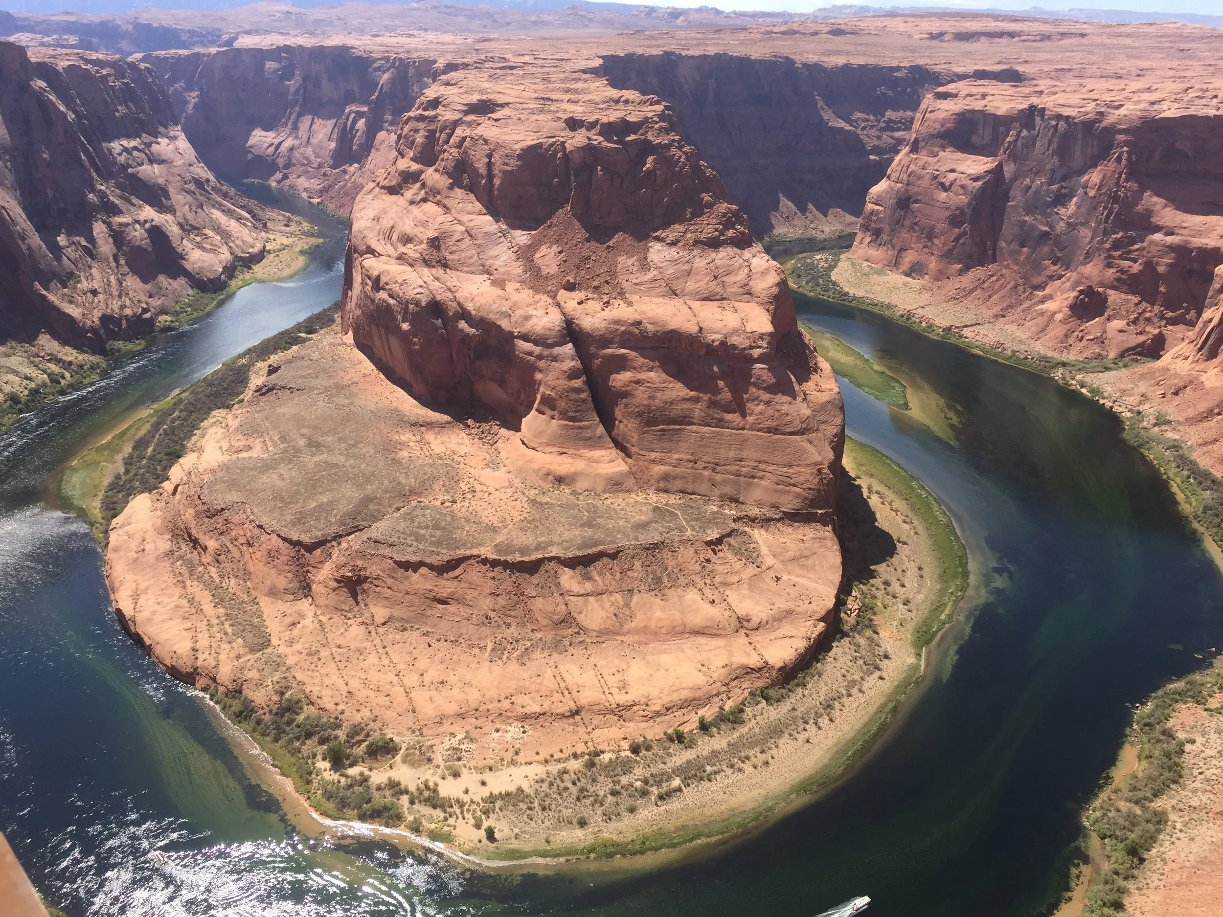
Horseshoe Bend
2. Horseshoe Bend
Location: Page, Arizona (just off US-89)
Overall Experience: 8/10
Horseshoe Bend is the famous curve of the Colorado River about five miles downstream from the Glen Canyon Dam, near the town of Page. You’ve seen it on Instagram. It’s a short walk from the parking lot to the overlook, and in the last ten years it’s gone from a quiet local spot to one of the most crowded viewpoints in the Southwest.
Go early. We arrived near sunrise, and for about fifteen minutes we had the overlook nearly to ourselves. By 9 AM there were hundreds of people. By 11 there were thousands.
A few conscious-travel notes:
The city of Page now manages the overlook and charges a parking fee. There are guardrails in a few spots but most of the edge is unprotected, and people have died here taking photos. Don’t be one of them — stay back from the edge, not just for your own safety but because emergency response out here puts rescuers at real risk.
Page itself sits just across the highway from the Navajo Nation border. If you’re staying in town for a night or two, choose Navajo-owned restaurants and businesses over the big chains when you can. The tourism economy in Page leans heavily on the Navajo Nation next door — supporting the people who live here is the lowest-friction thing you can do.
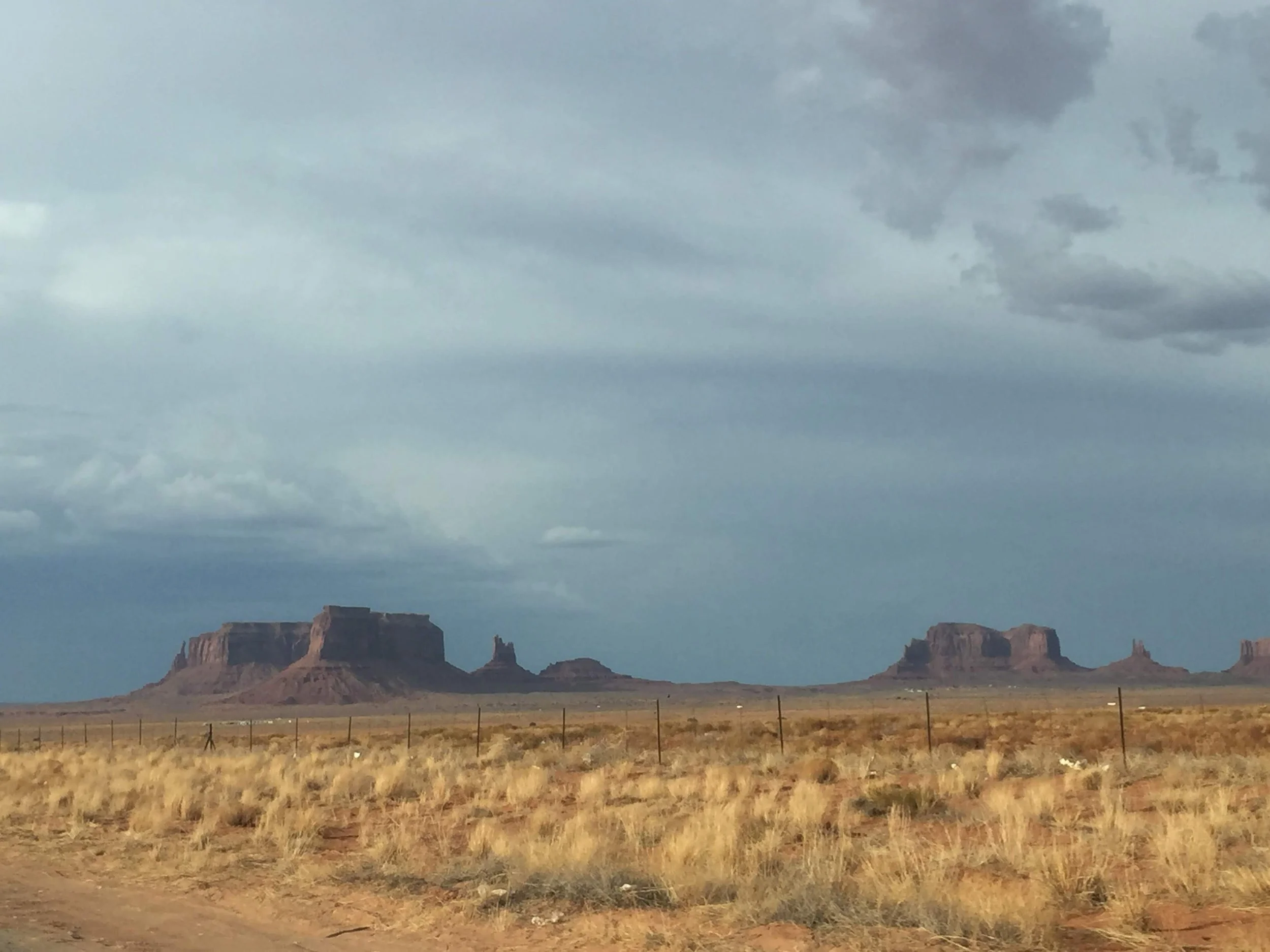
Olijato, Monument Valley
3. Monument Valley / Tse’Bii’Ndzisgaii
Location: Monument Valley Navajo Tribal Park, US-163, Utah/Arizona border
Overall Experience: 10/10
The drive north from Kayenta on US-163 is one of the great approaches in American road-tripping. About twenty minutes before you reach the park, the horizon starts to fill with sandstone towers — Sentinel Mesa, Mitchell Butte, the Mittens — and the road straightens out into that long, dead-flat section Forrest Gump ran down in the movie. We caught it with a monsoon storm breaking up behind the buttes, light dropping sideways through the clouds.
The most important thing to know about Monument Valley is this: it isn’t a national park. It’s Monument Valley Navajo Tribal Park, managed by the Navajo Nation, and it sits inside sovereign Navajo land. National Park passes don’t work here. You pay a per-person entry fee (and a small vehicle fee if you’re driving the loop) directly to the Navajo Nation Parks & Recreation Department, and that money funds the park, Navajo jobs, and cultural preservation. The Navajo name for this valley is Tse’Bii’Ndzisgaii — the Valley Within the Rocks.
A few conscious-travel notes, because this one matters:
Hire a Navajo guide. The 17-mile self-drive loop is beautiful, but the best parts of the park — Ear of the Wind, Mystery Valley, the petroglyphs, Hunts Mesa — are only accessible with a licensed Navajo guide. This isn’t bureaucratic red tape; it’s sovereign tribal law, and the access is restricted for a reason. It also means your tour fee goes directly to a Navajo family business. Good operators include Monument Valley Tours by Three Sisters, Roy Black’s Guided Tours, and Dineh Bekeyah Tours.
Buy from the roadside vendors. In the mile before the Visitor Center, Navajo artisans set up tables selling jewelry, weavings, pottery, and traditional food. Stop. Buy directly. Pay cash if you can. This is as close to direct-to-artisan as tourism gets.
No drones. No climbing. No off-trail hiking. The formations are sacred, and Navajo law is strictly enforced. Several of the monuments are not to be climbed, photographed for commercial use, or approached closely — ask your guide before you do anything you’re not sure about.
Ask before photographing people. This is where Navajo families live and work, not a movie set.
Monument Valley is not a landscape you visit. It’s a landscape you’re hosted in. Spend the extra hour on the guided tour, spend the extra dollars at the vendor tables, and remember all the way through that you’re a guest.
These three places get photographed more than almost anywhere else in the United States, and most of that photography is done fast — a quick stop at Mather Point, a sunrise shot at Horseshoe Bend, a drive-by of the Mittens. You can do the whole circuit in two days if you’re efficient.
We’d argue against being efficient. These are landscapes that were shaped over hundreds of millions of years and have been meaningful to the people who live here for all of recorded memory. The generous thing — for you, for the land, for the communities who host you — is to slow down. Pay the Navajo Nation fees without grumbling. Skip the helicopter. Buy the jewelry directly from the woman who made it. Hire the guide.
Travel further. Respect the land. Leave the lightest imprint you can.